The 2012 election demonstrated what many people could have guessed: rural states voted for Romney while densely populated states voted for Obama.
Many have offered explanations — everything from the presence of top universities in cities, to the prevalence of immigrant and African American populations. Perhaps the Republicans should consider running a Hispanic or African American candidate in 2016; but will that really help? Is identity the issue, or is it more about values?
Or is something more basic at work? Studying election results county by county, a stunning pattern emerges.
Population Density: the Key to Voting Behavior?
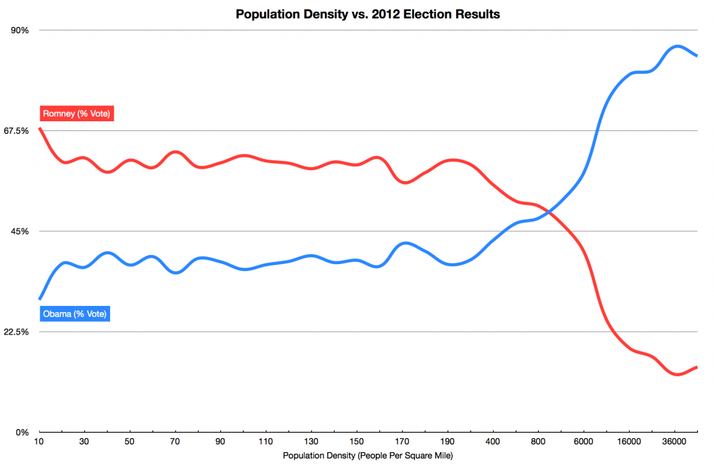
Curious about the correlation between population density and voting behavior, I began with analyzing the election results from the least and most dense counties and county equivalents. 98% of the 50 most dense counties voted Obama. 98% of the 50 least dense counties voted for Romney.
This could not be a coincidence. Furthermore, if the most dense places voted overwhelmingly for Obama, and the least dense places voted overwhelmingly for Romney, then there must be a crossover point: a population density above which Americans would switch from voting Republican to voting Democratic.
So I normalized and graphed the data, and there is a clear crossover point.
At about 800 people per square mile, people switch from voting primarily Republican to voting primarily Democratic. Put another way, below 800 people per square mile, there is a 66% chance that you voted Republican. Above 800 people per square mile, there is a 66% chance that you voted Democrat. A 66% preference is a clear, dominant majority.
So are progressive political attitudes a function of population density? And does the trend hold true in both red and blue states?
Red States and Blue States
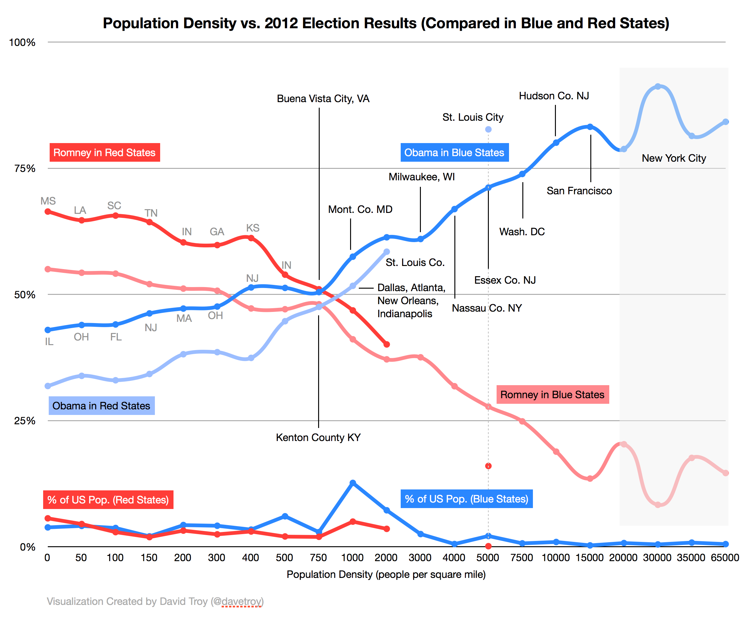
Separating the results from red states and blue states, we can see that while each has a slight preference for their ultimate candidate of choice, on a local level voting behavior is still directly correlated to population density.
Studying this graph, two important facts are revealed. First, there are very few cities in red states. Second, the few dense cities that do exist in red states voted overwhelmingly democratic.
Atlanta, New Orleans, St. Louis, Dallas, and Indianapolis are all in red states — and they all voted blue. And there are no true “cities” in red states that voted red. The only cities in red states that didn’t vote blue were Salt Lake City and Oklahoma City. And by global standards, they are not really cities — each has population density (about 1,000/sq. mi.) less than suburban Maryland (about 1,500/sq. mi.).
Historically, one can argue that red states have disproportionately affected election results by delivering a material number of electoral votes.
Red states simply run out of population at about 2,000 people per square mile. St. Louis is the only city that exceeds that density in a red state. It voted overwhelmingly Democratic (82.7%). In contrast, blue states contain all of the country’s biggest and densest cities: Washington DC, New York City, San Francisco, Baltimore, Milwaukee, Philadelphia, Boston, etc.
Red States Are Just Underdeveloped Blue States
As cities continue to grow in red states, those cities will become more blue, and ultimately, those states will become more purple, and then blue. The Republican party says it’s about growth and prosperity; the best way to achieve that in red states is through the growth of cities.
If you follow the red state trend lines, you can clearly see that any dense, fast-growing cities that might emerge in red states will be very likely to vote blue. The few that do already exist already vote blue. How would these new cities be different and cause them to vote red?
Red state voters generally prefer low-density housing, prefer to drive cars, and are sensitive to gas prices. Once population density gets to a certain level, behaviors switch: high-density housing is the norm, public transit becomes more common, and gas use (and price sensitivity) drops.
Red state values are simply incompatible with density.
Cities Are the Future
Globally, cities are growing rapidly as people move from rural to urban areas in search of opportunity. By 2030 it’s estimated that cities will grow by 590,000 square miles and add an additional 1.47 billion people.
Only subsidized suburban housing and fuel prices are insulating the United States from this global trend, and even with these artificial bulwarks, there is no good reason to think that America’s future lies in low-density development.
Density is efficient. Density produces maximum economic output. An America that is not built fundamentally on density and efficiency is not competitive or sustainable. And a Republican party that requires America to grow inefficiently will become extinct.
While the Republican party is retooling in the desert, it should carefully consider whether its primary issue is identity politics or whether its platform is simply not compatible with the global urban future. If that’s the case, an Hispanic candidate running on the same old Republican platform will simply not resonate. The Republican party must develop a city-friendly platform to survive.
Cities are the future and we need candidates from both parties that understand that reality.
The next question: why does population density produce these voting behaviors? Is the relationship causal or correlated? Probably both. I’ll explore this in my next post.
Data Source: US Census 2010 (population density by counties); Politico.com election 2012 results by County.


